Banjarumale Hills is home to “Malekudiya” tribal people living deep inside the forests on the Western Ghats in Dakshina Kannada and is located on the Charmadi Ghat Road (Mangalore-Chikmagalur Road). Banjarumale is one of the thick forest in Charmadi range. One will find 11 hairpin curves while traveling from Mangalore-Chikmagalur, in the Charmadi and Banjarumale is located in the 9th hairpin curve. On a total, it is 110 kms away from Mangalore.
How to Reach Banjarumale
It is 18 km from Kakkinje, the nearest village situated on the Mangalore-Chikmagalur Road, which could be reached by road. It takes over one hour to reach Banjarumale from Kakkinje by jeep. If one does not opt to go by road, then one has to get off a public transport at Ninth Cross on the Charmadi Ghat Road and walk for about 10 km inside the forests on the mud road.
However, since a private estate has fenced the route, there is a need for any trekker going on this route to take prior permission from the private estate managerial staff. Just an oral permission is not sufficient as the private estate party demands for written and sealed permission to pass through the route.
Banjarumale Photo Gallery
Elephant corridor
It takes over one hour to reach Banjarumale from Kakkinje by jeep. However, the journey to Banjarumale on road is not easy. One has to be careful about wild elephants that suddenly appear from the forests. The main highlight of the region is that is the home of pachyderms, which make appearances frequently.
Apart from being rich in vegetation, one more reason why the elephants make their way to Banjarumale is the fact that most of the elephants are shunned by the villagers from Ambattimale and Yilimale range. One can see herds of 13 or more elephants together during certain seasons.
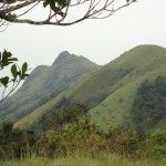
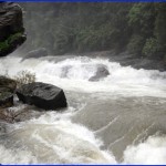
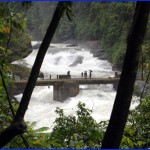
Banjarumale’s topography is mainly valleys, painted with rivers and falls. Aniyur river, Vatehalla falls, Kallarbi falls are some of the must see in the region.
Kallarbi falls in specific is the most beautiful place in the range because water flows over a big rock and the intensity of water slightly varies during dry season and monsoon. This region has ‘Kallu Baale’ growing in abundance adding to the beauty of the area.
Banjarumale gets its name because the region was said to be hostile for human settlement because of density of forest. However, today it is home for over 21 Malekudiya tribal families.
Kumbakallu, Minchukallu, Barimale etc are some of the other hills worth seeing in the area.
Map and Driving Directions to Banjarumale
[mappress mapid=”20″]